Land East of the
Boship Roundabout
Lower Horsebridge
Thank you for showing interest in the potential development of
land to the east of the Boship roundabout at Lower Horsebridge.
Hertfordshire Holdings Ltd is a James family-owned company which has a land interest at Lower Horsebridge, Hailsham including this proposal site.
The James family also founded Marchfield Developments Ltd and was a corporate partner in nearby land development proposals for a 460-home site, north of Hailsham, which has been subsequently acquired and built by Bellway Homes and Orbit Homes as ‘Hellingly Green’.
Introduction
Hertfordshire Holdings Ltd, who recently submitted a planning application for homes and publicly accessible green space on land to the east of the Boship roundabout, would like to hear your views on a proposal to also include a discount food store on part of the site.
Hailsham does not currently have a discount food store, such as Aldi or Lidl.
Hertfordshire Holdings Ltd is seeking your feedback on whether land to the east of Boship roundabout is an opportunity site for this, to complement its proposals for new housing at this location.
If a food store is proposed, this will reduce the number of homes proposed on the site.
The site
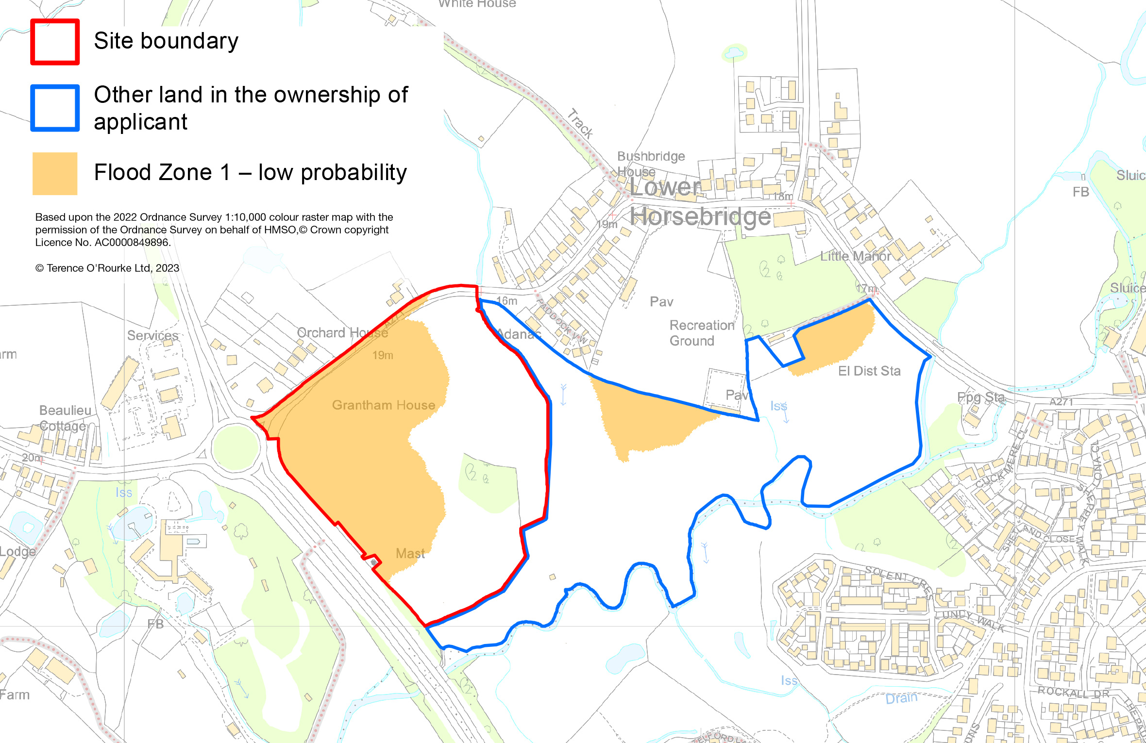
The proposal site lies to the south west of Lower Horsebridge village and is adjacent to the Boship roundabout, at the northern end of the A22 Hailsham bypass.
The site is fronted by the A271 Horsebridge Road and involves a land parcel that is situated outside of the river Cuckmere
flood plain.
Hertfordshire Holdings also owns wider land along the river corridor which extends
around the southern side of Lower Horsebridge village. This may offer potential for ecological improvements or potentially a southern extension to Lower Horsebridge recreation ground.


Flooding
Is the site subject
to flood risk?
However, parcels of higher lying land to the immediate east of the Boship roundabout, immediately south of the recreation ground at Lower Horsebridge, and to the east of the electricity substation are in ‘Flood Zone 1’, are at low risk of river flooding (less than 0.1% chance of flooding in any year)
and at very low risk or surface water flooding (less than 0.1% chance of flooding in any year).
The proposed location for built development east of Boship roundabout is within the low risk Flood Zone 1 area.
The proposed development site is close to the Cuckmere river and the Lower Horsebridge stream with their associated floodplains. In times of high rainfall the river levels risk above the banks and spread into the natural floodplain south of Lower Horsebridge. Flooding occurs regularly in these locations, particularly in the winter months, as many local people will be aware. This is river flooding.
Similarly, in the immediate period following a particularly heavy rainfall event, surface water may pool on fields and on roads until it can drain away. This is surface water flooding.
Hertfordshire Holdings Ltd owns a swathe of land south of Lower Horsebridge. A large portion of this land is within the floodplain, as shown on the attached flood risk map.
What flood risk assessments have been undertaken?
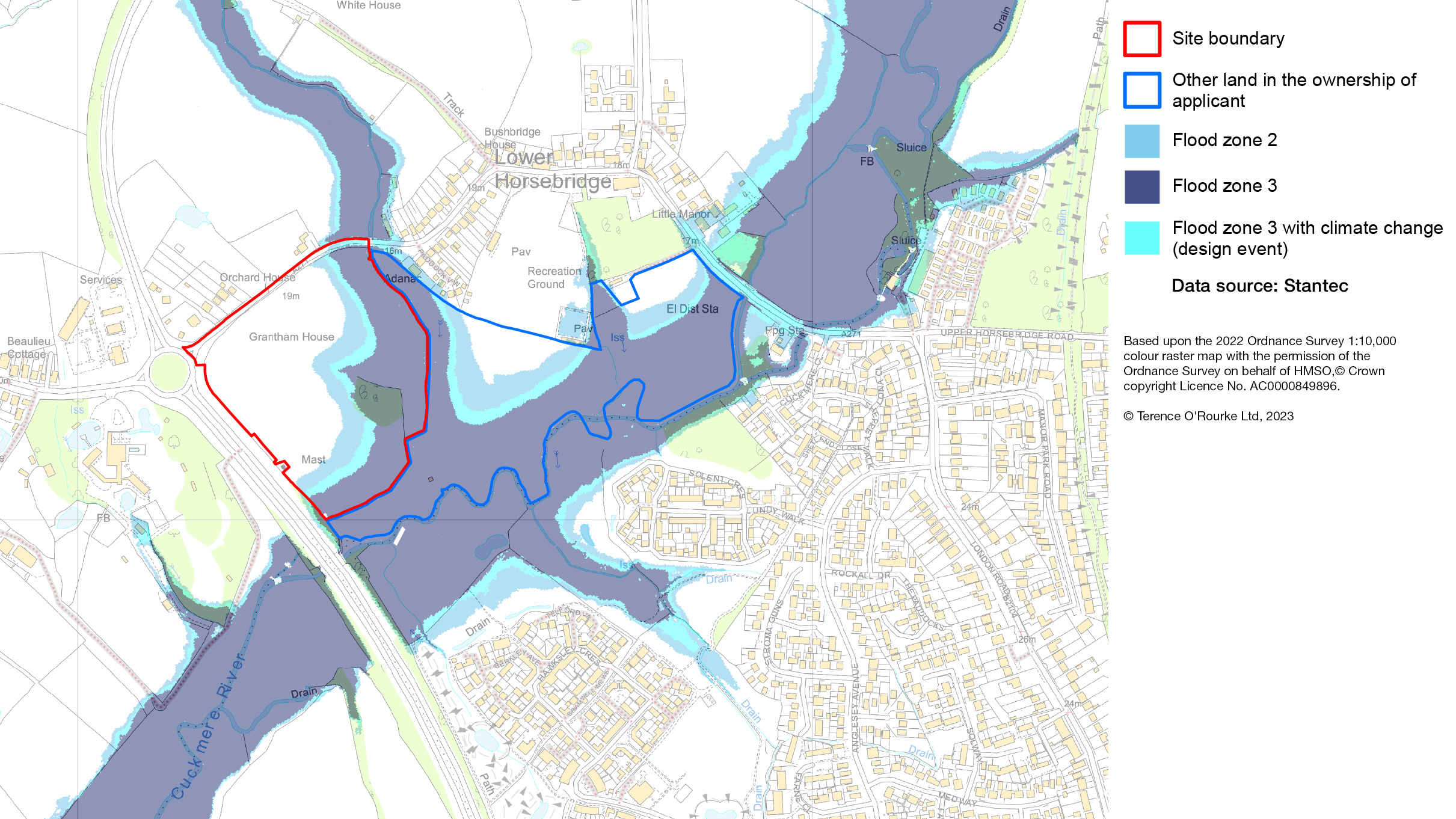
A publicly accessible website shows the ‘national flood map for planning’, which is based upon data provided by the Environment Agency. This can be accessed at http://flood-map-for-planning.service.gov.uk. For the Cuckmere river and its tributaries, the Environment Agency flood mapping is based on a broadscale national assessment of river flood risk.
Notwithstanding the availability of this information, Hertfordshire Holdings’ flood risk specialist Stantec has prepared a more detailed flood risk model, using data obtained from physical survey of the site, the watercourse, bridges and culverts in addition to historical records of flooding and water level data from Environment Agency gauging stations.
The model helps to develop a better understanding about how a river and its catchment behaves during flood conditions and enables an assessment of the impact of natural and man-made features on flood risk.
In developing the model there is also a need to build in an allowance for predictions of climate change and the impacts this will have on future flood risk.
The computer model can calculate the water level for different river flow conditions and where water will flow when the river channel capacity is exceeded. Where the performance of the model closely matches real world observations there is increasing confidence in the results.
Hertfordshire Holdings’ flood risk model identifies that the areas subject to flood risk in an extreme event (1 in 1,000 year event or an event with a 0.1% probability of occurrence in any year) are slightly greater than shown on the Environment Agency flood map. Therefore it takes a cautious approach and the development has been planned taking this into account.
The mapping of the river flood zones is shown above. The zones that have been modelled show the following:
- Flood zone 1: Locations in flood zone 1 have a low probability of flooding. This means in any year land has a less than 0.1% chance of flooding from rivers or the sea (areas on the map shown outside Flood Zones 2 & 3)
- Flood zone 2: Locations in flood zone 2 have a medium probability of flooding. This means in any year land has between a 1% and 0.1% chance of flooding from rivers.
- Flood zone 3: Locations in flood zone 3 have a high probability of flooding. This means in any year land has a 1% or more chance of flooding from rivers
The Environment Agency provides guidance on the impacts of climate change and how this will impact peak river flows in watercourses. Over the lifetime of the development peak river flows are anticipated to increase in the Cuckmere and Pevensey Levels Management Catchment. The impacts of this on land that has a 1% or more chance of flooding from rivers is shown on the map above.
Will development on the site increase flood risk?
No.
It is recognised that there is significant local concern around new developments, the increase in area that is built upon, and the potential implications of this for flooding.
The development has been planned to avoid areas that are at risk of flooding. There is also a requirement of national and local planning policies that new developments do not increase flood risk elsewhere. To manage runoff from paved surfaces and the roofs of buildings a surface water drainage system has been designed to mimic the sites natural drainage regime using a sustainable drainage system.
The Environment Agency, Wealden District Council’s Engineer & Countryside Officer
and East Sussex County Council (as Pevensey and Cuckmere Water Level Management Board and Lead Local Flood Authority) have all confirmed that the recently submitted proposed development is capable of managing flood risk effectively.
How will the proposal manage flood risk?
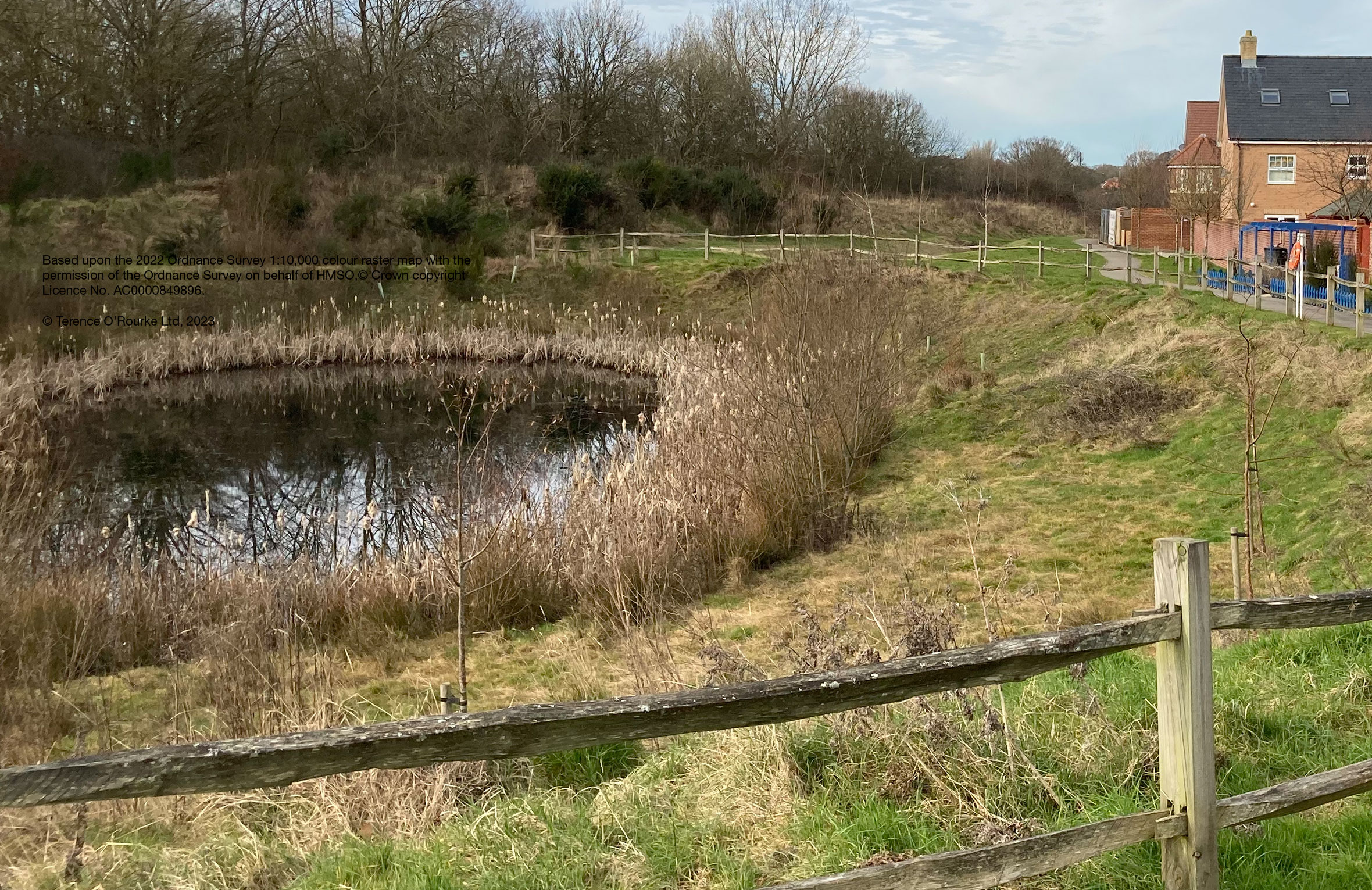
In the Hellingly and Hailsham area, attenuation ponds are a typical approach used for surface water runoff from hard surfaced areas in new developments to manage and avoid downstream flooding.
Sometimes known as balancing or retention ponds, these features are a key element of sustainable drainage systems.
They provide temporary storage areas for surface water draining from a development. Flows which then discharge into the local watercourse from the pond are attenuated, i.e. reduced and released at a slow rate.
The rate of discharge from the attenuation basins is restricted to a specific rate. This means that for more significant events, the rate of runoff from the site will be reduced in comparison to the current rates of runoff from the site.
Proposals
This section sets out two proposals for your consideration:
1. A proposal for new homes and publicly accessible green space
2. An alternative proposal for new homes, publicly accessible green space, and a discount food store (please scroll down to see)
1. A proposal for new homes and publicly accessible green space
In December 2022, Hertfordshire Holdings Ltd submitted a planning application seeking outline planning permission for a development of up to 124 homes (houses and low-rise apartments), associated infrastructure and open space on this site.
The proposal takes advantage of the location of the site immediately adjacent to the town of Hailsham and the village of Lower Horsebridge with direct access to a main local movement route.
The submission of the residential proposal, which includes policy compliant levels of affordable housing, is a response to the requirement to provide a short term supply of housing in Wealden District, pending the preparation and adoption of a new Wealden Local Plan.
In developing the masterplan, Hertfordshire Holdings Ltd undertook rigorous assessments to provide positive responses to the site’s opportunities and constraints, including:
- Consideration of points of access for vehicles, pedestrians and cyclists and links to local bus stops
- Using land that is not subject to flood risk and developing sustainable drainage infrastructure, and
- Introducing new planting and green routes to enhance site biodiversity.
Landscape, open space and biodiversity benefits
- An extensive area of green space will be become accessible to the public
- New hedgerows and new areas of scrub and woodland
- Enhancements to the Lower Horsebridge stream corridor including new areas of streamside planting to enhance biodiversity
- A positive contribution to the wider River Cuckmere corridor, to maintain the river corridor character and enhance biodiversity
- Attractive green amenity and play space
- Two wildlife ponds
- Tree planting within the developed area to help create a greener environment
- A network of paths (footpaths and potentially a cycle path)

2. An alternative proposal
Hertfordshire Holdings Ltd are committed to exploring options that maximise the social, economic and environmental benefits that this unique site can deliver.
Hertfordshire Holdings Ltd are seeking your comments on an alternative proposal to include a discount food store with new homes and greenspace on the same site.
The following information sets out more detail about discount food stores and the emerging proposal.
What is unique about discount food stores?
The discounters – of which Aldi and Lidl are the largest in the UK – include fresh foods and premium products, however they differ from the big stores by offering a reduced range of permanent product lines (c. 2,000) compared with major supermarkets that may offer 40,000+ products.
Aldi and Lidl stores require smaller buildings than the large food retailers with up to around 2,000 sq m of floorspace. By comparison, a typical Tesco ‘Superstore’ is in excess of 2,700 sq m and a Tesco ‘Extra’ may be more than double that size again.
The focus of the discounters is on reducing the costs of their operations so that savings can be passed on to consumers.
Low cost
Aldi and Lidl are among the cheapest supermarkets in the UK.
Source: Which?, December 2022. Average basket price based on a basket of 48 popular groceries.

In a September 2022 YouGov poll, one in six Britons (16%) said they had changed their main supermarket specifically because of the rising cost of living, with Aldi and Lidl being the biggest recipients of these switchers.
Does a discount food store make sense for Hailsham?
The towns of Hailsham and surrounding new neighbourhoods, such as Hellingly Green, are continuing to grow.
The town centre has healthy levels of trade and provides a service centre role for a much wider area. It includes supermarket chains Waitrose, Tesco, Asda and Iceland.
However, there is currently no discount retailer (such as Aldi or Lidl) in the immediate Hailsham area.
Despite being an established town and retail centre, Hailsham is constrained by the limited volume of space available for development.
While retail demand in Hailsham is strong, lack of existing supply and strong transport links have given rise to a significant outflow of retail spend to Eastbourne, Tonbridge and Lewes. The nearest Lidl food store is in Polegate, and Aldi has a store further away at Eastbourne.
The sequential approach to locating retail uses is set out in the National Planning Policy Framework (NPPF). The proposal site is classed as an “out of centre” site for this policy. Out of centre sites can be considered where town centre and edge of centre sites are not available.
The site stands out from any other site in the existing residential and employment areas of Hailsham as it is both sufficiently large to accommodate the proposed development and is available now.
A proposed store would bolster the local economy, enhance the retail sector in Hailsham and provide around 40 new jobs.
A proposal for new homes and a discount food store
Hertfordshire Holdings Ltd are exploring the level of local interest in a scheme that could deliver a discount food store to complement a development of new homes in this location.
In developing the concept masterplan, Hertfordshire Holdings Ltd has undertaken rigorous assessments to provide positive responses to the site’s opportunities and constraints, including:
- Consideration of points of access for vehicles, pedestrians and cyclists and links to local bus stops
- Using land that is not subject to flood risk and developing sustainable drainage infrastructure, and
- Introducing new planting and green routes to enhance site biodiversity.
The site proposal involves a discount retail store of between 1,800 sq m and 2,200 sq m floorspace in size together with approximately 60 homes. The scheme also involves an on-site green space area for public access of 3.8 hectares, which is larger than the area proposed to be built on.

Landscape and open space
The new area of publicly accessible green space will be located on the south and eastern parts of the site. An area of existing woodland will be retained with new blocks of native trees, scrub, new hedgerow and specimen tree planting provided throughout the open space and in amenity space around the site. New areas of species rich grassland will replace the low diversity semi-improved grazed grass.
Overall, the proposals will achieve biodiversity net gain at the site.
A network of paths (footpaths and potentially a cycle path) will be provided through the open space area. A play area will also be located in the open space. It is likely to be in an accessible location within easy reach of the residential dwellings.
Future management and maintenance of the landscape, open space and biodiversity areas will be secured via a private management company or, alternatively, through adoption by the district or parish council.
Hertfordshire Holdings also owns wider land to the east along the river corridor, beyond the boundary of this proposal, which extends around the southern side of Lower Horsebridge village. This may offer also potential for ecological improvements and potentially a southern extension to Lower Horsebridge recreation ground.
Access, movement and parking
A new single point of vehicular access will be provided from the A271 in a position dictated by highway design considerations. The illustrative layout also shows potential pedestrian and cycle route provision within the site.
The car park for the store would be sized to readily accommodate required levels of customer parking, with disabled spaces and the potential to introduce electric vehicle charging points. Typically houses would be provided with on plot parking including a number of garage and carport parking spaces.
Comments
Please let us know your thoughts about the proposal to deliver homes and a discount food store on land to the east of Boship roundabout at Lower Horsebridge.
- What are your thoughts on the proposal for a discount food store, new homes and open space at this Lower Horsebridge site?
- Do you have any thoughts on appropriate use of wider land in the floodplain to the east, beyond the boundary of this proposal, which is also within the same ownership?
Please send your comments to foodstore@torandco.com
Support for a discount food store
By “adding your name” you are registering as a supporter of a proposal to include a discount food store on this site.
Register with us by filling out the form.
GDPR: We take your privacy seriously. Your personal data will not be used for any purposes without your consent. At the end of the consultation process, we will remove your contact details from our information systems.
